
Carlingford
Carlingford is a medieval walled town on the southern shore of Carlingford Lough in County Louth, set beneath the Cooley Mountains and looking across the water to the Mournes. Discover Ireland describes it as a place to explore medieval streets, sample local oysters, and take time by the lough and hills. On a private day tour from Dublin it makes a rewarding stop, either on its own or combined with Proleek Dolmen and the wider Ireland's Ancient East landscape north of the capital.
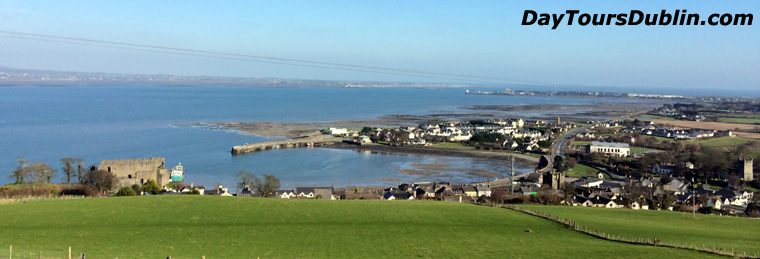 Carlingford is a picturesque medieval town on the southern shore of Carlingford Lough.
The town still keeps its medieval layout of narrow lanes and small streets. Tholsel Street leads to the last of the old town gates, and a short walk links harbor, castle rock, and Market Square. Heritage Ireland notes that Carlingford lies in the shade of Slieve Foye, a mountain linked in legend with the sleeping giant Finn Mac Cumhaill.
King John's Castle
King John's Castle, also known as Carlingford Castle, stands on a rocky outcrop above the harbor and dominates the town. It was established around 1200, probably by the Norman baron Hugh de Lacy, who later became Earl of Ulster. He was the son of another Hugh de Lacy, the Anglo-Norman lord who built Trim Castle, Ireland's largest Anglo-Norman fortress, in the Boyne Valley. Carlingford Castle takes its familiar name from King John of England, who seized the de Lacy lands in 1210 and is said to have stayed here. The castle was enlarged and altered in later centuries. From the walls there are wide views across Carlingford Lough toward the Mourne Mountains.
The fortress remained a key point of defense for centuries. Discover Ireland notes that Hugh O'Neill, Earl of Tyrone, attempted a surprise attack in 1596, and the site changed hands several times in later centuries. The Jacobites fired on the castle in 1689, and William of Orange is said to have housed wounded soldiers here after the Battle of the Boyne. Access today is by guided tour in season, arranged through the Visit Carlingford Tourist Office at the Station House.
Carlingford Heritage Centre
The Carlingford Heritage Centre is housed in the restored medieval Church of the Holy Trinity and tells the story of the town from Viking settlement around the 9th century through the Norman and later medieval periods to the present day. Discover Ireland recommends allowing about an hour to an hour and a half for the exhibition, with maps, illustrations, photographs and an audio-visual presentation. It is a useful starting point before walking the streets and castle approaches.
Dominican Friary
The Dominicans were established in Carlingford in 1305 under the patronage of Richard Óg de Burgh, 2nd Earl of Ulster, with the friary dedicated to St Malachy. Dissolved in 1540 by Henry VIII, it later became the focus of a repossession struggle between the Dominicans and Franciscans in the 1670s, settled in favor of the Dominicans by Oliver Plunkett. The friary was abandoned in the 18th century when the community moved to Dundalk. The remains today include a nave and chancel divided by a tower, with possible traces of domestic buildings to the south, including a mill, mill race and mill pond.
Town Wall
A charter of 1326 from Edward II allowed the bailiffs of Carlingford to levy a toll for building the town walls. Little of the circuit survives, but the remaining stretches include externally splayed musket loops, a reminder of the arrival of firearms in Ireland in the late 15th century.
The Tholsel
The Tholsel, or town gate, was used to levy taxes on goods entering Carlingford. In the 18th century it also served as a town jail. It remains one of the most photographed medieval structures in the village and marks the threshold between harbor approaches and the old street pattern.
Taaffe's Castle
Taaffe's Castle, also known as the Merchant House, is a fortified town house that local tradition links with the mercantile Taaffe family, who became Earls of Carlingford in 1661. Its position beside the harbor suggests a trading depot on the ground floor, with living quarters above.
The Mint
The Mint is a fortified three-story townhouse in the center of Carlingford, once belonging to a wealthy merchant family. Its most striking feature is a set of five highly decorated limestone windows, with patterns and motifs that show the influence of the Celtic Renaissance on 16th century Irish art.
Ghan House
Ghan House is a Georgian house built by William Stannus in 1727, surrounded by castellated walls and a guard tower. The first-floor drawing room has rococo plasterwork of flower garlands and medallion busts, said to represent Stannus family ladies. Today Ghan House operates as a guest house and cookery school.
Market Square
Market Square is now the main street of Carlingford. Records of a weekly market here go back to 1358. It sits at the meeting of Dundalk Street and River Lane and remains the natural hub for cafés, pubs and short walks between the castle, Tholsel and harbor.
Cooley Peninsula and the Táin
Beyond the town walls, the Cooley Peninsula offers mountain and shoreline scenery that Discover Ireland highlights for walking and cycling. The Táin Way is a marked loop of about 40 km (25 miles) around the peninsula, following quiet roads, forest and mountain paths with views over Carlingford Lough, the Mournes and Dundalk Bay. Shorter options from Carlingford include stretches of the Carlingford Lough Greenway and local mountain loops beneath Slieve Foye.
Cooley is also the landscape of the Cattle Raid of Cooley, the great Ulster Cycle tale in which Queen Medb of Connacht and Cú Chulainn contest the Brown Bull of Cooley. Even a brief stop by the lough or a drive toward Omeath or Greenore helps place the medieval harbor town in that wider legendary and coastal setting.
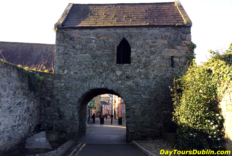 The Tholsel Carlingford.